
|
|
 |
The Hawaii State Civil Defense Department was kind enough to give me some information that they are working on about the Military History of the park. They also allowed me into some areas that are not generally accessible to the public to take some photos. I've combined that with photos and information from other places (particularly the US Army Museum, Hawaii) to create this page. The Hawaii DLNR, Division of State Parks has also been very helpful. As of September 24, 2009 most of the page is finished pending new information. I'm working on getting a copy of A Military History of Diamond Head and Fort Ruger, Part I, Coast Defense Journal, Vol. 19, No. 2 (May 2005), pp. 4-41; Part II, Coast Defense Journal, Vol. 19, No. 3 (August 2005), pp. 4-46. by William C. Gaines which has some background not easily available elsewhere. I also have a few more photos to organize. The island of Oahu was formed about 3,000,000 years ago when two shield volcanos erupted to create the Waianae and Koolau Mountain ranges that form most of the island. Since then they have been seriously eroded, resulting in the cliffs, ridges and valleys that you see today. The hotspot that created those eruptions is now far to east. As it shifted east it created the islands of Molokai, Maui and Lanai. It is now the source of the continuing eruptions on the Big Island of Hawaii and an eruption that is creating a new island even further east, still far below the surface of the ocean. About 300,000 years ago a new series of smaller eruptions created the Tuff cones on the southeast side of Oahu: Punchbowl, Diamond Head and Koko Head. It was also the source of the lava flow that created the area southeast of Diamond Head known as Blackpoint. It's interesting to note that the eruptions in some places covered coral reefs that are now over 100 feet above sea level, meaning that the sea level was at least that much higher than it is now. The Geological Society of America bulletin, Volume 17 (1905) contains an article by C. H. Hitchcock discussing the formation of Diamond Head, Black Point and the rest of Oahu. There is also a photo taken from the top of Diamond Head in 1905 showing some of the rim and Blackpoint in the background, scroll up a couple of pages to see it. Approximately 1,500 years ago (500 AD +/- a few) the first known Polynesians arrived by canoe and began to settle the islands. In 1778 Captain Cook was the first Westerner to discover the islands, and he named them the Sandwich Islands. In 1898 Hawaii was annexed by the United States and in 1900 it became a US Territory. Just over 100 years ago the US Government purchased Diamond Head Crater, setting the stage for the Military development of the crater. There is more history of the Crater in this August 6, 2008 Honoluluweekly.com article. For a brief overview about the amount of fortifications scattered around Oahu see this Honolulu Advertiser article. If you're at all interested in military history [and even if you're not] you should consider visiting the US Army Museum at Fort DeRussy at the west end of Waikiki. The Museum is located in Battery Randolph, a massive gun battery built about 1911. Although the guns and battery were bigger and the layout is different, there are many similarities to some of the structures at Diamond Head. The building has been restored and most of it is open for visitors. There are excellent exhibits about the Battery, the buildup of the military presence in Hawaii, local Hawaiian battles, World War II in the Pacific and more. And of course tanks, guns and other equipment. Some of the Exhibit is available online. Additional outstanding resources are the book Defenses of Pearl Harbor and Oahu 1907-50, By Glen Williford and Terrance McGovern and the web site and publications of the Coastal Defense Study Group. From the About the CDSG page:
If there are old fortifications near where you live, they probably have information about them. And they are always looking for new members and sources of information. Both the US Army Museum at Fort DeRussy and the CDSG would be interested in any material that people are willing to share. Photos of old posts that your grandfather took while stationed somewhere, letters about them, anything you might have. In 1905 the US Government paid $3,300 for Diamond Head Crater and some of the surrounding area, totalling over 720 acres. Although there are a lot of variables which can make this number inaccurate, adjusting for inflation since 1905 the price would have been approximately $78,101 in 2008. This area was developed into Fort Ruger, which along with Fort DeRussy (on the west end of what is now Waikiki) and some other facilities was the backbone of the U.S. Army Coastal Artillery defense system for a number of years. Fort Ruger was considered to be the eastern end of the defenses of Honolulu and the military bases in the area. Battery Harlow on the north slope of the crater and Birkhimer inside the crater are designed to fire to the south over the crater at ships at sea. Some of the guns at Diamond Head had a 360 degree field of fire and the range to fire over the Koolau Mountains to the north and reach Kaneohe Bay. In addition to providing protection from sea based attacks, another purpose was to defend Honolulu from ground based assaults from the eastern end of the island. That's why some of the batteries face east and/or north. And like many of the beaches on Oahu, the area around Diamond had bunkers and pillboxes along it's length in case of an enemy landing attempt. A friend who grew up near the by then abandoned batteries on Blackpoint remembers concertina rolls of barbed wire above their house, the old battery positions beyond that, and gun emplacements along the beach. As early as 1915 the Army was reevaluating it's defense strategy based on lessons being learned in WWI and the effects of new technology. A major factor was the development of aircraft since many of the old batteries had no camouflage or protection from aerial attacks. A large number of Batteries and Forts all over the world were being deactivated. This included some of the guns and batteries at Diamond Head and the surrounding area. Other facilities were upgraded or improved. One surprising outcome was the addition of anti-aircraft batteries to the rim of the crater before aircraft could even reach the islands, and before the advent of true aircraft carriers. Railway guns and mobile guns of various sizes and types also became a bigger factor in the defense strategy. The Diamond Head Facilities continued to be important though, and many of them are still in use today, although not necessarily for strictly military use. For some good information about the Diamond Head facilities and other military fortifications on Oahu, see Defenses of Pearl Harbor and Oahu 1907-50, By Glen Williford and Terrance McGovern. According to the Hawaiian Encyclopedia:
From other sources, a list of armaments in place at Fort Ruger (Diamond Head) in 1941 shows:
For some images of guns similar to those mounted at Diamond Head see the photos on this page from the Coastal Defense Study Group. The third photo down is a 6 inch gun, the fourth photo is an anti-aircraft gun mount position, and the fifth photo is a 4 position 12 inch mortar battery that would have been similar to those in Batteries Harlow and Birkhimer. For some archived footage of 12 inch mortars being fired, see this clip from the CDSG on YouTube. That page also links to several more videos from the CDSG. Construction started in 1907 on the Fire Control Station and a group of gun batteries inside, on and outside the crater. The diagram on the right shows the layout of the Fort as of 1934. Click the thumbnail for a larger version.
By about 1916 there were also a series of Anti-Aircraft and 2.24 inch/6 pound gun positions on the top of the crater rim stretching along the east and north sides. The actual guns weren't mounted though, they were kept in storage, ready to be moved to the positions in case of an emergency. These guns were intended to protect the main batteries and Honolulu from ground assaults from the east end of the island. Many of these batteries, guns or mounts were determined to be obsolete and removed by the early 1920s. Also by sometime in the 1920s residential development around Diamond Head became a problem for practice firings, and the gun crews usually went to other locations to practice. Starting in 1910 at least 6 60 inch search light stations were eventually added on and around the rim of the crater. Most if not all of the searchlights were housed in underground concrete pits, and raised for use. A sliding metal roof over the pit would be pulled to the side when the light was used. One of the structures still exists on the crater rim, but it's in bad shape and outside of the area that can be visited. Another one apparently remains below the crater on the ocean side, but is very difficult to get to, and is also in bad shape. All the searchlights had their own underground generator rooms. Some modifications were also made about the time of World War II, most notably the addition of Battery 407 through the crater wall on the south side. None of the guns around Diamond Head Crater were ever fired during war. As the War progressed and moved further from the Islands, and due to limited resources, plans to upgrade or build new facilities were put on hold. The remaining guns were all removed between 1940 and 1950 and scrapped, there are none left that I'm aware of. Of all the old military facilities in and around the crater, only the Fire Control Station is currently accessible to the public. The Diamond Head Park Master Plan includes steps to open a great deal more of the facilities, but it will take years for even part of that to happen.
Battery Harlow was the first structure built at Fort Ruger, starting in April 1907 and finishing by March 1910. Click the Thumbnail on the right to see an album with 36 photos and descriptions.
The Battery is designed in the shape of a capital letter E with a pair of 4 mortar gun pits between the arms of the E. The E itself is a solid building with thick concrete walls and covered with many feet of soil. There are fire control facilities, offices, store rooms, powder and shell rooms, and an underground power room. The Battery received power from a 25kW generator run by a 50 HP gasoline engine. There are lantern alcoves throughout the structure to be used in the event of a power failure. The center leg has a mechanical communication system that was used to signal firing information to the gun pit crews on either side. There is a pair of "built in" concrete megaphones in the wall, and two sets of mechanically cranked numbers that the Fire Control officers could use to signal the Elevation and Azimuth settings. Page 37 of Defenses of Pearl Harbor and Oahu 1907-50 has a diagram of Battery Harlow showing one pit firing and one pit loading their guns. You may need to scroll up to see it. There's also list of the various sections of the Battery. There is more information in the Photo Album. The Kapahulu Tunnel [also referred to as the Mule Tunnel] was constructed in 1909. It runs 580 feet through the north wall of the crater, sloping fairly steeply uphill into the crater. Originally it was 5 feet wide and 7 feet high which is what was required for mules. Mules were used primarily to pull narrow gauge rail cars loaded with material in and out of the crater and to the various construction points. In 1922 the tunnel was enlarged to 15 feet wide by 14 feet high. A Fire Control Switchboard that had been in a shed outside the tunnel was moved into a room carved into the wall about 100 feet from the outside end. In 1932 the tunnel was enlarged again, to 17 feet high to allow truck traffic. During the widening a larger cavern was cut into the wall of the tunnel at the downhill end, creating rooms for a Harbor Defense Command Post. Those rooms are now used by the Hawaii Red Cross as storage. The Kapahulu Tunnel is used only when the Kahala Tunnel is closed for repairs or problems.
The Fire Control Station was an engineering marvel for it's time.
Station 1 at the top level was First Battle Command. Station 2 was below that and was the First Fire Command and served Battery Harlow. Station 3 was the Second Fire Command and served Battery Dudley at Fort DeRussy, Station 4 served Battery Randolph at Fort DeRussy. The lowest level is the longest, but is mainly tunnel to the front of the Station, with an observation room at the end of it. The image on the right is just a place holder and will soon link to a photo album.
Before they built the Station they had to build a path to it, and that was a huge job in itself. The Army Corp of Engineers constructed a 5 foot wide, 7 foot high mule tunnel through the north rim of the crater, then a path across the floor, and finally a steep set of switch backs leading up to a set of 79 stairs. At the top of those stairs is a 225 foot long, 5 foot wide, 7 foot high tunnel which slopes steeply upwards. It's very possible that the 79 stairs below the tunnel were only added after construction was well along since that tunnel size is the same as the original mule tunnel through the rim. A lot of material had to be hauled to the top of the rim, and mules were the way to do it. They were helped by a winch station that was built at the top of the switch backs and used to haul material up to the that point, but from there it still had to moved to where it was needed. All the tons of concrete, rebar, steel grates, shutters and doors, pipe and conduit, and everything else used in the Station had to be hauled up the hill. To construct the Station they cut a big notch in the peak of the crater using a chute to dump the removed material inside the rim of the crater. There's a blurry copy of a circa 1909 photo showing the chute on the Ready Aim, Fire poster on the reader board near the restrooms. Once the hole was finished a 4 story high concrete building was constructed in it, then a shaft to the top of the peak. The building is long [front to back] and narrow, and it appears that the hole was cut to just the right size. Because of the construction the very highest point of Diamond Head is not natural rock. After the building was finished it was covered with dirt and camouflage material including real and false rocks set in cement. You can see this material as you leave the 3rd level of the observation post to go to the top along the trail. Many of the artificial rocks were hollow shells and have fallen apart. From the trail outside you can see the edge of the excavation where it changes from concrete and camouflage to natural rock. The Station almost certainly had electricity and probably water right from the start. The first electricity came to the City of Honolulu in 1886. By 1888 there were street lights in some parts of town, and by 1890 a significant number of homes has electricity. Many industries or areas had their own generators by then, so it's likely that the Army would have used one to power the Fire Control Station and main batteries. Battery Harlow which was completed before the Fire Control Station had it's own power plant. Phone lines would have been easy to string and were in common use by the military at that time. There are also water pipes in the Station that look like they were part of the original construction. Judging by the number of conduits and pipes of different ages that run along the trail in various places the systems were probably upgraded at least a few times over the years as technology improved. The Station itself was in use through WWII. Near the Station but out of the area that's accessible there are foundations for some old buildings. Some reports say that there were separate enlisted mens quarters, latrines, a switchboard room, battery storage room and power room. Some of those may have been located in the rooms along the halls of the Station, or where the foundations are. I've also seen reports that the enlisted quarters were in a ravine further down the hill. There is a power station along the trail near the bottom of the ravine, but I haven't found anything to indicate when it was built and whether or not it contained a generator. Battery Birkhimer was built between 1915 and 1916 at a cost of $190,000 and was also a bunker style battery.
Batteries Dodge and Hulings Built in 1915 these batteries were each armed with a pair of 4.72 inch guns.
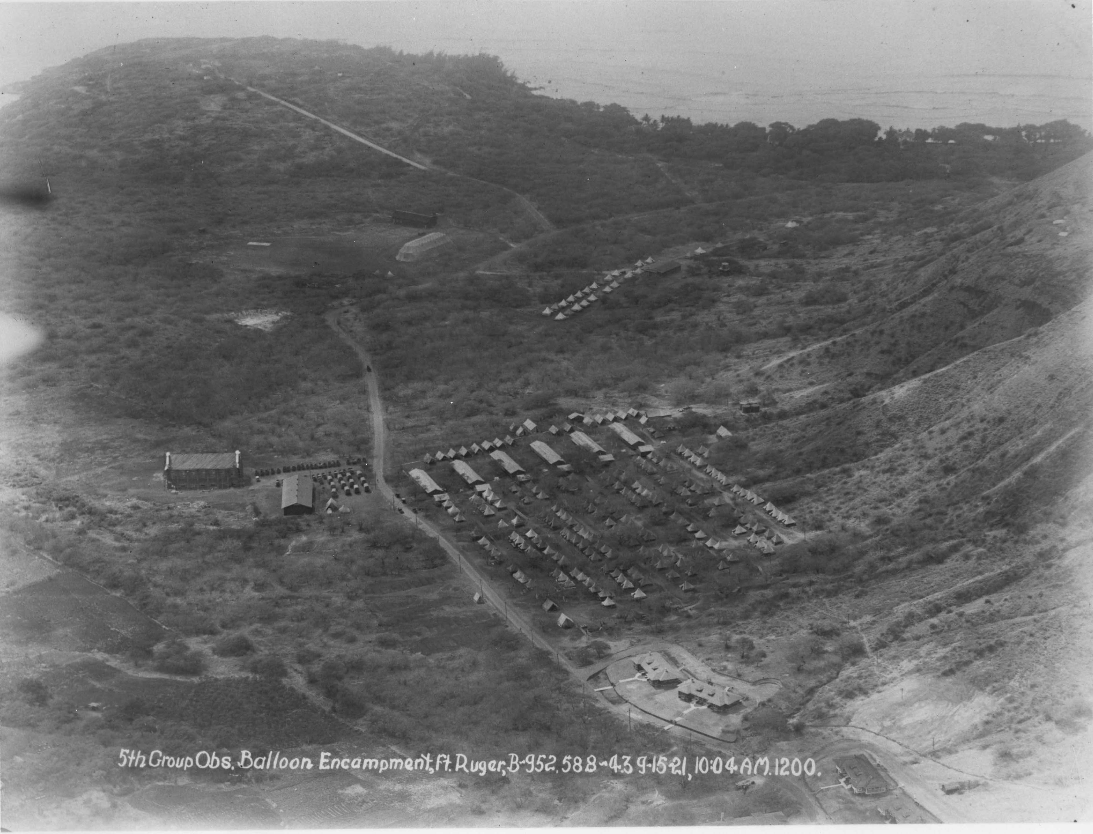
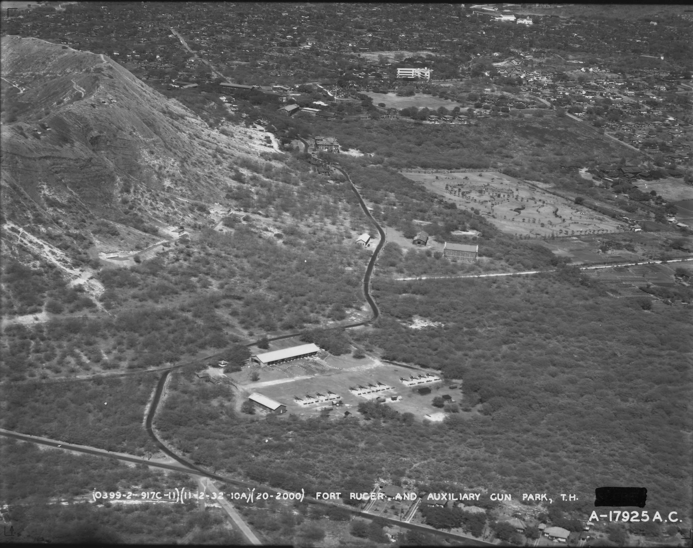
Battery Mills was built on the Kupikipikio Point Reservation which was not technically part of Fort Ruger but was administered by it. That Reservation was on the lava point now known as Blackpoint and has long since been removed. Roads and houses now cover the area where it was. Battery Mills existed from 1916 to 1925 and was armed with 2 5 inch Seacoast guns. There was a reinforced magazine for munitions, a plotting room/command bunker and an underground power room which would have had a generator. Those guns were eliminated from the Army's inventory so the Battery was decommissioned. A December 12, 1921 report to the Senate from the Committee on Military Affairs was about Bill H.R. 4598 which was a request from the War Department for authorization to exchange some land that the military owned but didn't need for some land they needed. The Bill passed the House on August 15 1921 and was recommended for passage by the Senate Battery Granger Adams replaced Battery Mills and consisted of 2 8 inch railway guns on either side of a protected powder and shell magazine, along with a Commander's Station and power room. Clicking the thumbnail on the right will open a 582 KB aerial photo of Blackpoint taken on March 2, 1938. This photo is courtesy of the US Army Museum, Hawaii. The two guns are mounted at Granger Adams, and you can see the concrete protected underground magazines with the Battery Commander's Station above them, between the two gun positions. In the trees to the left of Granger Adams is the old Battery Mills, with the guns removed several years earlier. At the bottom right corner is the entrance to the underground plotting room that would direct the fire of the guns. The rectangular house along the shore was under construction at the time of the photo and is still there. The area where the Batteries were is now a subdivision. As near as I can tell the battery was approximately where the green arrow is. Battery 407 was constructed in 1943-1944 and the original plan was to mount guns salvaged from the USS Arizona. The tunnels were completed, including some work to make them gas proof, and the mounts for the guns were prepared, but the guns were never installed. According to a number of references there were plans to use several guns from the Arizona including two gun turrets. But it turned out that only the two turrets were salvageable, and even they had problems causing major delays in getting them installed. Everything had been under water for months and when the parts were salvaged it wasn't done with re-use in mind. Cuts were made in the wrong places, parts were missing, the guns were 30 years old and had been modified making replacement parts nearly impossible to procure, and more. The turrets were eventually installed in Battery Pennsylvania and Battery Arizona on Oahu. Only one was fully completed and test fired, and it was soon deactivated. Battery 407 is currently used by the Hawaii National Guard. Photo Album coming soon, right now it's just the thumbnail. Battery Ruger was built in 1937 and decommissioned in 1943. It contained four GPF 155-mm. mobile cannons on Panama mounts. I haven't been able to determine the location of this battery yet. A Balloon Section was located on the east southeast corner of Fort Ruger according to the 1934 diagram. During the early 1900s tethered balloons were used for observation and there were apparently at least two balloon units on Oahu, one at Fort Ruger and one at Fort Kamehameha. The 3rd Balloon Company arrived May 6, 1920 and was assigned to Fort Ruger. Balloons could go up as high as 3,500 feet allowing a much greater viewing range than anything else in the area. They could actually see further than the guns could shoot at that time. They were affected by weather though, so couldn't always be counted on when needed. There are some photos of balloons and facilities in Hawaii at this State of Hawaii page. Both of these photos are courtesy of the US Army Museum, Hawaii. This Sept. 15, 1921 aerial view of the Balloon Encampment is looking south towards Black Point, and the road to Battery Mills is visible. By the time this aerial view of an Auxiliary Gun Park was taken on Nov. 2, 1932 the only remaining sign of the Balloon Encampment is the white building next to the road in the center of the photo. All the other similar buildings are gone. The two buildings across the road are also visible in the 1921 photo. The gun park is in the center foreground. The 12 guns stored there would have included the ones to be mounted on the crater rim if needed. Visible just below the crater rim are Batteries Hulings and Dodge. Also visible on the inside of the crater wall is a road that appears to go up to and along the top of the rim, then presumably down the outside of the crater. This would be the road that the guns of Battery Birkhimer were hauled in on. Below Battery Dodge are three widely separated, duplicate buildings. The foundation of at least one is still there, it's just below the entrance to the Kahala Tunnel. The blacked out word at the bottom of the photo appears to be The Kahala Tunnel was built through the east side of the crater wall during the 1940s and it is now the primary access to the crater. It is wider than the Kapahulu Tunnel by a few feet, but is only 13 feet high at the center, meaning that large vehicles need to drive down the middle of the tunnel. There is a foot path on the south side of the tunnel but it's narrow too. Click the thumbnails to see larger versions.

7 Storage Tunnels were dug into the outside slope of Diamond Head along the northeast side. These tunnels have been used by a number of agencies over the years. They are numbered 0-6 and two of them are visible from the road up into Diamond Head. Tunnel 0 is/was used for communications, the others are now storage. Most of the storage tunnels have high powered ventilation systems. The design varies somewhat, but none of them go through the crater wall entirely. Some of the sources for material used on this page, in no particular order. This list is not complete and will be updated when I can:
|
| Home | FAQ | Military History | Photo Gallery | Links | Contact Us, Privacy policy, etc |
| © 2008, 2009 DiamondHeadHike.org If you have a question or comment you can: <email me> Validated by HTML Validator (based on Tidy) Content Updated September 24, 2009 Minor update Feb 14, 2012 |


